
VIP member
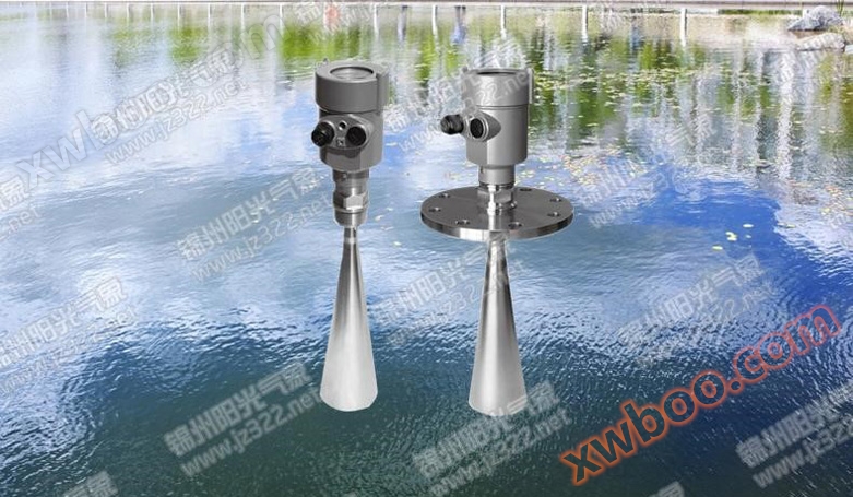
RL30 radar water level gauge
The RL30 radar water level gauge is a high-precision surface water level measurement product with surface wave filtering processing. The measurement i
Product details

System Introduction
Alias: Laser River Water Level Gauge
The RL30 radar water level gauge is a high-precision surface water level measurement product with surface wave filtering processing. The measurement is not affected by atmospheric temperature, pressure, air density, wind, precipitation, or relative humidity, and has extremely high stability. Low power consumption and maintenance free design, suitable for unmanned field automatic station applications. The product has flexible working mode configuration. There are 5 types of radar water level scoring, namely RL30 (measurable distance of 30 meters), RL25 (measurable distance of 25 meters), RL15 (measurable distance of 15 meters), RL10 (measurable distance of 10 meters), and RL05 (measurable distance of 5 meters).

Features and Characteristics
1. Sunshine Smart Cloud Platform
Real time cloud monitoring and storage of device data 24/7. Users do not need to monitor data online. Data collection and calculation are completed by the cloud platform on the server side. They only need to turn on the monitoring system when they need data, log in to the platform, and synchronize with the cloud data platform to view real-time and historical data information on both PC and mobile devices.
I will maintain your product
Customers who purchase our company's monitoring system products can access the cloud platform for free and provide free data services

2. Not affected by atmospheric temperature, pressure, air density, wind, rainfall, and relative humidity;
3. Not affected by pollutants and sediments in water;
4. Not affected by changes in water quality;
5. Measurement accuracy can reach millimeter level
6. The measurement range can reach 30 meters (the measurement distance can be adjusted according to the actual measurement range)
7. High stability;
8. Non contact measurement method, not affected by floating debris;
9. Low maintenance cost;

System Principles
The radar pulse is emitted from the radar water level sensor antenna, which receives the reflected pulse from the water surface and records the time (T). Since the propagation speed of electromagnetic waves (C) is a constant, the distance to the water surface (D) can be obtained. The time from emission to reception of electromagnetic waves is proportional to the distance to the water surface, and the relationship is as follows: D=CT/2. The calculation of time (T) adopts a special time-domain conversion technique, which converts nanosecond level time measurements into millisecond level time measurements, greatly improving measurement accuracy. Measurements are taken 55 times per second, followed by digital filtering to minimize the impact of water waves on the measurement results. The measurement results are equivalent to static water level measurements.
Technical Specifications
1. Principle: Pulse radar
2. Frequency: 6.8GHz
3. Beam angle: 14 °
4. Sampling frequency: 55 times per second
5. Measurement range: 5, 10, 15, 25, 30 meters
6. Blind spot: 0.5 meters
7. Measurement accuracy:<0.1% (<3cm)
8. Repeatability: ± 2mm
9. Resolution: 1mm
10. Voltage: 12VDC (± 10%) or 24VDC (± 10%)
11. Current: (at 12VDC)<40mA (at startup)<31mA (at operation)
(At 24VDC)<22mA (at startup)<20mA (at operation)
12. Output: RS232, RS485, TWI at 12VDC: 4-20mA at 24VDC
13. Environmental temperature: -40 to+70 ℃
14. Relative humidity: 0-100% RH
15. Size: ¢ 110mm × 600mm
16. Weight: 2.6Kg
17. Antenna Material: Stainless Steel 316L+PTFE
18. Protection level: IP67
Application Industry
The RL30 radar water level gauge adopts a horn antenna design to reduce power consumption and has a wide range of input voltages. It is specifically designed for outdoor work. The superiority of the RL30 radar water level gauge in applying radar measurement principles makes it suitable for the following working environments: water level measurement in reservoirs, rivers, lakes, wetlands, water level monitoring where water quality is prone to change, ditches containing a large amount of floating debris and sediment, places producing a large amount of aquatic plants, solar power supply, remote field work, and areas prone to flash floods.

Product physical image


Online inquiry
-
Contacts
-
Company
-
Telephone
-
Email
-
WeChat
-
Verification Code
-
Message Content
-