
VIP member

KSG3000T Intelligent GPS Fine Positioning Management System
Introduction to KSG3000T Intelligent GPS Fine Positioning Management System. Currently, many logistics, insurance, traffic dispatch, safety and other
Product details
KSG3000T Intelligent GPS Fine Positioning Management System
System Introduction
At present, many logistics, insurance, transportation scheduling, safety and other industries have positioning requirements, and many enterprises and institutions also have positioning management requirements for their operational resources or management objects. However, they suffer from the large investment in positioning systems, high operating costs, and complex maintenance that are difficult to achieve. Therefore, our company has developed this intelligent GPS refined positioning management system to meet the requirements of positioning management in various industries.
The basic uses of the intelligent GPS refined positioning management system include real-time positioning of personnel or vehicles, scheduling management, alarm handling, online inquiry services, mobile inquiry services, SMS inquiry services, etc. The system is suitable for urban, regional, and national networking use, and is suitable for government, group, enterprise and institution, private vehicle users, and special population positioning use. This system can effectively improve work efficiency, achieve convenient management, and maximize profits.
The service targets of the system can include electric vehicles, special populations and pets, public security organs, security companies, bus companies, special industries (various engineering vehicles, concrete mixing vehicles, rental vehicles, fire trucks, emergency vehicles, dangerous goods transportation vehicles), and companies with a large number of field personnel.
At present, there are mainly the following application areas:
Vehicle positioning management
Vehicle positioning and management are achieved through a dedicated GPS terminal (model: KGPST300V) installed on the vehicle.
The main functions are as follows:
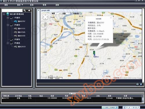
1. Implement location management for various types of vehicles, which can obtain real-time location and historical trajectory.
2. It can be combined with the onboard computer and card swiping system to achieve management of drivers and passengers, such as passenger permission management and driver attendance management. Passenger information can be reported daily and reports can be generated.
3. Administrators can remotely manage passenger permissions, driver attendance, and daily scheduling through the software platform
4. Management and processing of various alarm information, such as GPS no signal alarm electronic fence (area alarm), offset line alarm, overspeed alarm, timeout alarm, blockage alarm, overload alarm, vehicle abnormality alarm, manual alarm, etc.
5. Set up route and station information and manage vehicle operation information (such as vehicle punctuality and scheduling information).
6. Suitable for various types of vehicles, especially buses, school buses, and public transportation that require daily scheduling and passenger management.
7. Support voice card system to broadcast line information and location over the phone.
Enterprise management positioning communication
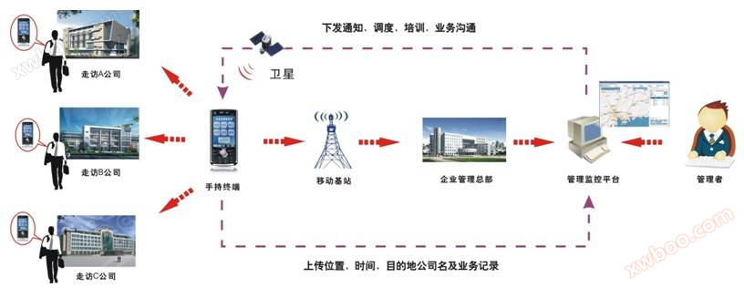
By installing a location management program on mobile phones, it can effectively help enterprises track and monitor the entire process of sales or field workers going out for mobile work. Enterprise managers can view and locate employees' daily travel routes, finely manage the execution of their daily work plans, facilitate scheduling and management, effectively improve work efficiency, and avoid management blind spots.
For sales or field personnel, just one GPS terminal can meet the communication needs with the superior leaders of the company headquarters, while maintaining constant contact with the headquarters. Through the platform, convenient travel navigation information and geographic information of surrounding public service facilities (such as gas stations, banks, hotels, restaurants, etc.) can be obtained, improving the individual operation ability and efficiency of personnel, and making it easier for enterprises to lead a high-performance, high-quality, and high combat effectiveness workforce.
The main functions are as follows:
1. Always locate at any time
Enterprise managers can locate the current location of subordinate employees at any time.
2. trajectory query
Just set a time period to query the activity direction and trajectory of an employee during this time period.
3. Attendance Report
Set a time period to view a detailed attendance list of an employee during a certain time period.
4. SMS Center
Used to send information to subordinate terminals of the enterprise.
5. map annotation
Salespeople can mark the geographical locations of all customers on electronic maps at any time through handheld terminals, making it convenient for enterprise managers to assess the progress of market development.
Special populations (pets) positioning system
The special population (pet) positioning system is designed for family members who require special care (elderly and children). The positioning program can be installed on existing mobile phones or an independent portable GPS terminal (model: KGPSM300) can be used.
Features of the special group positioning application:
1. GPS positioning can provide comprehensive activity trajectory tracking for children/elderly, allowing them to know where they are at any time.
2. It is possible to set up a certain protective activity area for children/elderly people, and once they leave the area, they will immediately receive a notification and warning.
3. When the elderly/children get lost while going out, timely navigation services can be provided to assist them.
For this group of elderly people, children, and others who need to prevent getting lost, other product forms such as watches and children's mobile phones can be developed. A GPS positioning device that can be designed as a collar for pets.
Intelligent GPS refined positioning management system software
WEB version
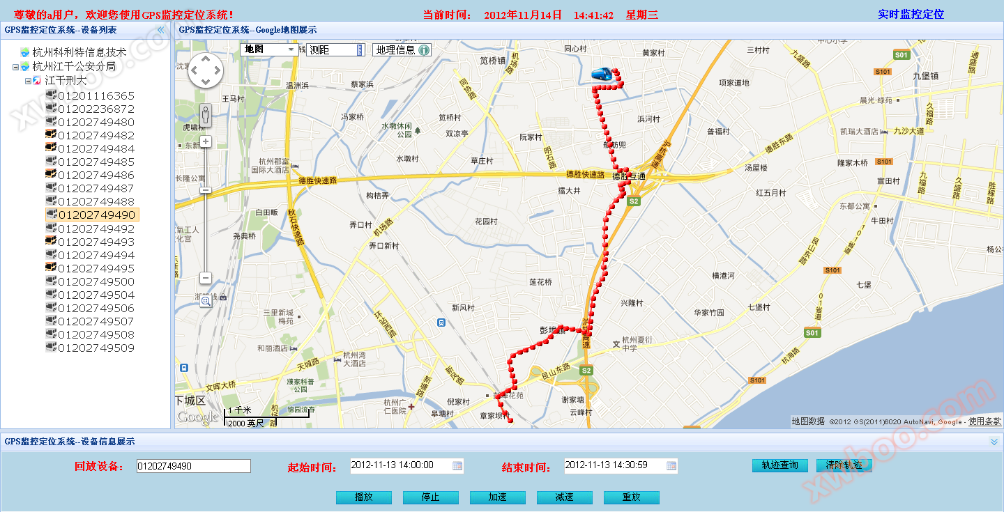
The system is based on the B/S architecture and can achieve real-time monitoring of location and status without downloading or installing a client. The system supports multiple map formats such as vector maps, satellite maps, and topographic maps. Both enterprise and individual users can achieve real-time monitoring of positioning targets, playback of historical trajectories, and adding annotations.
C/S version
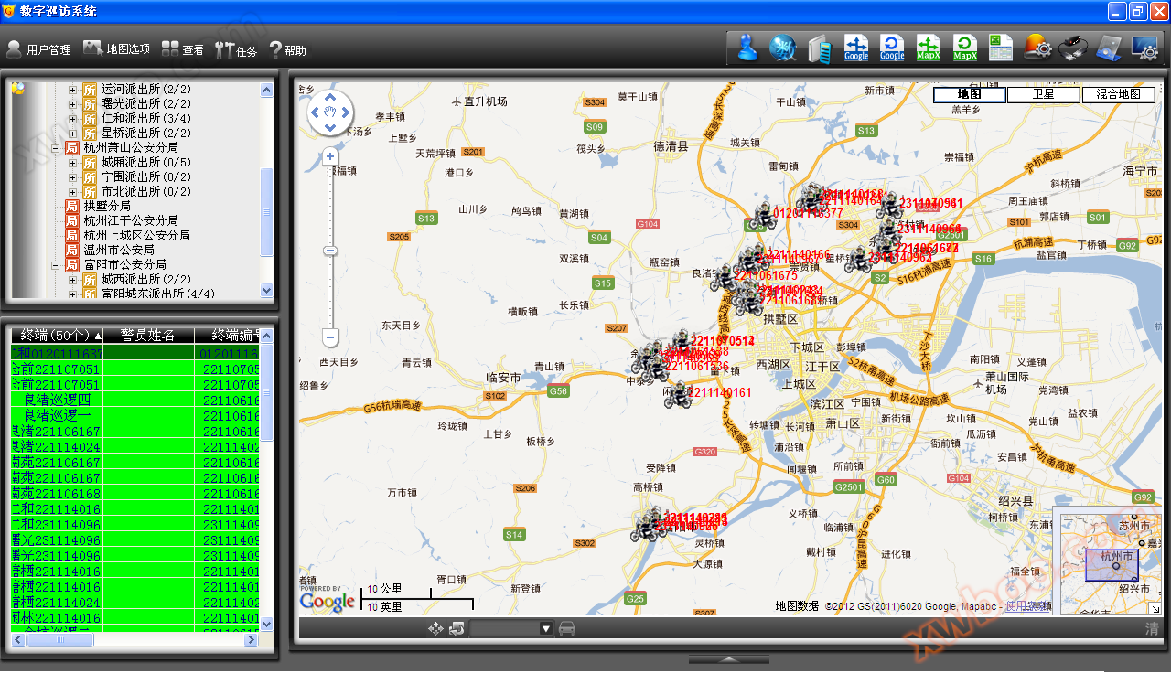
Based on C/S architecture, it runs fast and has rich functions. It can monitor and locate the position, speed, and dwell time of the target in real time, and has functions such as trajectory playback, overspeed alarm, cross-border alarm, remote fuel and power cut-off, remote photography, monitoring, adding information points, route planning, setting electronic fences, and historical route query.
mobile version
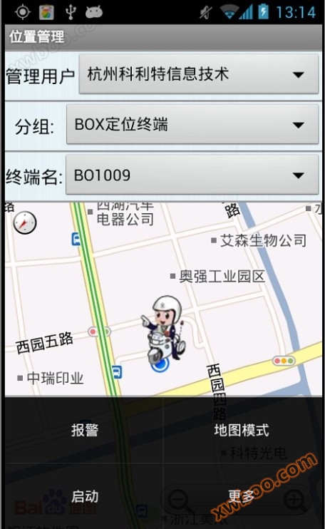
Real time status, location, speed, and other information of the target can be queried using a smartphone. The system automatically adjusts the display size of the map according to the size of the phone screen, and supports the zoom in and zoom out functions of the map. Real time status, speed, direction, location and other information of the target can be quickly queried through mobile SMS. This version can simultaneously obtain the GPS location of one's own mobile phone and report it to the server, without the need for users to equip a separate GPS terminal.
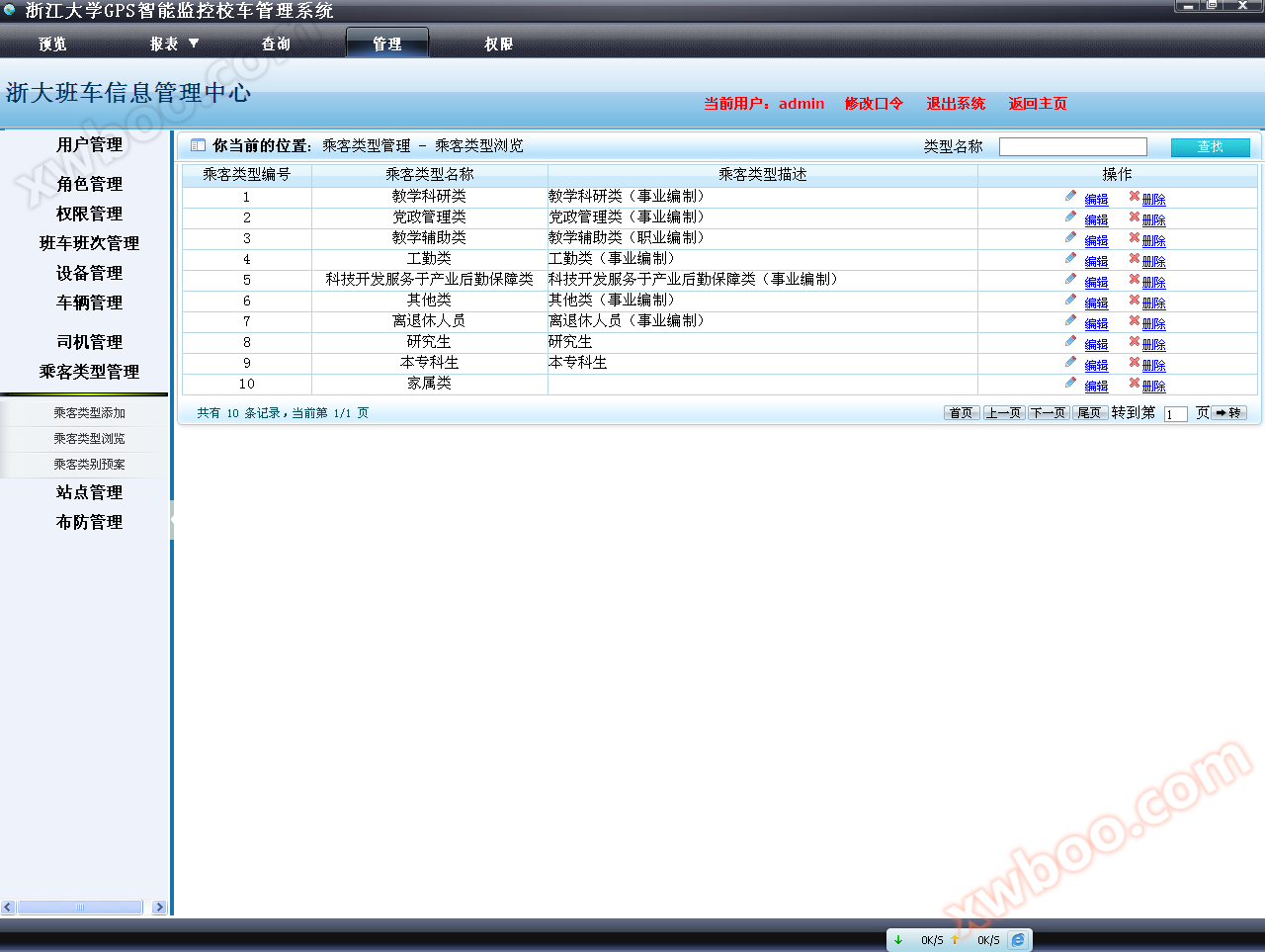
Scheduling Management Version
This client is suitable for applications such as shuttle buses, school buses, and public transportation that require daily scheduling and passenger management. In addition to basic GPS positioning and query functions, it also has the following functions:
1. Control passengers' boarding permissions through card swiping, and administrators can remotely adjust and set permissions through the software platform.
2. Report passenger boarding information and generate a report for administrators to conduct statistical analysis and scheduling.
3. Set up route and station information and manage vehicle operation information (such as vehicle punctuality and scheduling information).
4. Support voice card system to broadcast line information and location over the phone.
Online inquiry
-
Contacts
-
Company
-
Telephone
-
Email
-
WeChat
-
Verification Code
-
Message Content
-